
Flood Maps Are Changing
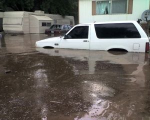
Everyone has some level of flood risk. When finished, the new flood hazard maps provide an updated picture of the risk. The level of flood risk can be different from neighborhood to neighborhood and even property to property. It is important for homeowners, renters, and business owners to learn how their risk is now shown, and how it will be shown when the new flood hazard maps become effective.
Know Your Risk
 When properties are mapped into high-risk areas (shown as flood zones labeled with letters starting with “A”), construction restrictions and flood insurance requirements may apply. In these areas, known as a Special Flood Hazard Area (SFHA), property owners with a mortgage through a federally regulated or insured lender will be required to carry flood insurance once the maps become effective. Some lenders may decide to require flood insurance purchase in advance of the maps becoming effective. Property owners who obtain and maintain flood coverage before the maps become effective may be eligible for cost-saving rating options provided by the National Flood Insurance Program. They should contact their insurance agent for more information and to learn about the available options. (Table)
When a property is mapped from a high-risk zone into a moderate- or low-risk zone (a zone labeled with the letter “X”), flood insurance will no longer be required once the maps become effective. However, the flood risk has only been reduced; it has not been removed. Property owners can maintain coverage by converting to a lower-cost Preferred Risk Policy (PRP), with premiums for residences starting at less than $200 per year. Again, property owners should discuss their options with their insurance agent. To learn more about flood insurance, talk with your insurance agent or visit www.FEMA.gov/NFIP.